[Typhoon No. 9 Approaching] To All Travelers in the Yaeyama Islands: What Past 'Fury' Teaches Us About What to Prepare for Now
![[Typhoon No. 9 Approaching] To All Travelers in the Yaeyama Islands: What Past 'Fury' Teaches Us About What to Prepare for Now](/media/blog/featured/2026/1c165be32b79e99f8ec3e110bb3ab43a.webp)
A Violent Typhoon is Approaching the Yaeyama Region
Violent Typhoon No. 9 (Bebinca) is approaching the Yaeyama Islands.
According to the Japan Meteorological Agency, as of the 6th, Typhoon No. 9 is near the Mariana Islands with a central pressure of 910 hectopascals and maximum instantaneous wind speeds of approximately 80 meters per second. The typhoon is expected to reach peak intensity around the 8th, then change course northward, with the closest approach to Ishigaki Island, Iriomote Island, Yonaguni Island, and other areas of the Yaeyama region expected around the 10th to 11th of this week. Wave warnings are expected to be issued in the Yaeyama region from around the 9th to 10th, with storm warnings likely around the 10th. Even from the 7th onward, while still distant from the typhoon, high waves with swells will begin to appear.
When you hear "typhoon in the southern islands," it might even sound somewhat refreshing, but typhoons in the Yaeyama region are truly in a league of their own. What can past records teach us—both travelers during their visit and those of us who live here—about what to expect? Let me look back through newspaper pages published by the company where I work.
Three Typhoons Etched in Islanders' Memories
September 2006, Typhoon No. 13 — The Night That Toppled 221 Power Poles
Maximum instantaneous wind speed of 69.9 meters per second on Ishigaki Island. This was an unforgettable typhoon that recorded the second-highest wind speed in history at the time, after Typhoon No. 5 "Vera" in 1977. The editorial office windows shattered and equipment was flooded. We rented several hotel rooms with emergency power supplies to carry out our editorial work. Incidentally, I was in my third year at the company at the time, and I was stunned by winds unlike anything I'd experienced in my hometown of Nagoya. In the end, we couldn't publish the newspaper.
The observation dome of the Ishigaki Island Astronomical Observatory, which had just opened in March of that year near the summit of Mt. Maesedake, was also damaged. The design was supposed to withstand winds of 100 meters per second, so it's not hard to imagine how fierce the winds must have been.
In the city center, vehicles overturned, and cars with loose parking brakes were seen rolling forward unmanned, pushed by the wind. The apartment where I lived lost electricity and water for a full week. The propane gas tank disappeared along with the metal chain that had secured it to the concrete wall.
In the Yaeyama region, 57 people sustained serious or minor injuries, and 68 houses were completely or partially destroyed. The strong winds toppled 221 power poles, leaving approximately 19,000 households without power. Recovery work proceeded through sheer manpower, but it took about a week for electricity to be restored. Combined with water outages and restricted water supply, total damages including agricultural crops exceeded 700 million yen. The municipal fire department responded 85 times, a record long remembered as "the highest in the district."
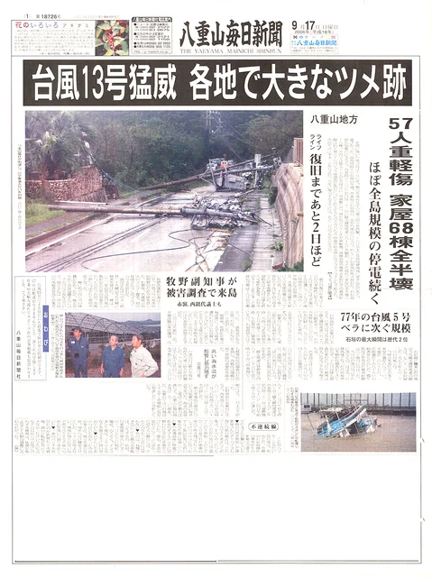
The newspaper page dated September 17, 2006. Due to the typhoon's impact, reporting was delayed by one day. Following this typhoon, a large generator capable of running the printing press was installed.
August 2015, Typhoon No. 15 — The Strongest Wind in Recorded History
Then, about nine years later, maximum instantaneous wind speed of 71.0 meters per second was recorded in Tonoshiro, Ishigaki City. It was the strongest wind ever recorded on Ishigaki Island since observations began in 1941. I had transferred to the Naha branch office with my family, so I didn't experience it firsthand.
In the city, cars overturned one after another, windows shattered, and steel-framed roofs were blown off, toppling power poles—such damage occurred repeatedly. At peak, approximately 21,500 households lost power, five people were injured, and 93 people from 46 households evacuated to designated shelters. In Tonoshiro, where our main office is located, 294.5 millimeters of rain fell in about 18 hours. Water restrictions were implemented throughout the city, truly a "direct hit on lifelines."
At this time, voices were heard from various parts of the island saying that when they entered the eye of the typhoon, "the sky briefly became bright." However, caution is essential. Our newspaper documented residents' testimonies that storage sheds that had survived the typhoon ten years earlier were toppled by the return winds after the eye passed.
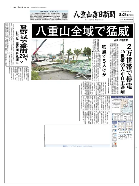
The newspaper page dated August 25, 2015. This year saw many typhoons strike Ishigaki Island and other areas of the Yaeyama region.
September 2015, Typhoon No. 21 — 81.1 Meters in Yonaguni, 4th Highest in National Recorded History
The following month of the same year, Yonaguni Island rewrote the records. The maximum instantaneous wind speed of 81.1 meters per second observed in Sonai, Yonaguni Town, was not only the maximum since observations began in 1956 but also ranked 4th in the entire nation's recorded history—an astounding figure.
In Yonaguni Town, nearly all households lost power, and close to half of telephone lines were cut. In the district, 68 flights were canceled at both Ishigaki and Yonaguni airports, affecting approximately 4,600 people. While 4,600 people may sound small, considering the numerous cancellations, the number based on reservations was likely much higher. Tourists stranded on Ishigaki Island were "stuck" in hotels, with voices heard lamenting, "The wind is so strong I can't even go to the convenience store." This was actually the fifth time that year a typhoon had approached Ishigaki Island—a year plagued by typhoons.
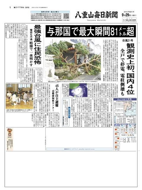
The newspaper page dated September 29, 2015. Yonaguni Island recorded a maximum instantaneous wind speed of 81.1 meters per second.
Before Your Trip and After Arriving on the Island
What past records show is that typhoons in the Yaeyama region bring travel itself to a halt through "wind," "power outages," "water outages," and "transportation disruptions." Typhoon No. 9 maintains strength similar to the 2006 and 2015 typhoons. It is now approaching the Yaeyama region with that strong intensity, and is expected to make closest approach from the 10th (Friday) to the 11th (Saturday).
To protect the safety of those already on the island, I've compiled a timeline of "when and what to do." Please keep this in mind to safely conclude your enjoyable trip.
Action Timeline Going Forward
The key to typhoon preparation is to work backward from the day of closest approach and act ahead.
7th (Tuesday) ~ 8th (Wednesday): Immediately cancel ocean activities
- Even if the sky is clear, strong "swells" are already reaching the sea. Absolutely do not approach beaches.
9th (Thursday): Deadline for stocking up
- Sea transport will stop, and logistics within the island will also halt. Secure necessary supplies by the morning of this day at the latest. Cup noodles and similar items are already running low. The newly renovated San-A Ishigaki City store has a larger backyard than before. Other mass retailers have also devised typhoon countermeasures, but there are limits, so early action is crucial.
10th (Friday) ~ 11th (Saturday): Do not step outside at all
- Air and sea transport will completely stop, and storm warnings will be issued. Spend the entire day safely indoors. Depending on location, winds strong enough to lift cars into the air are possible.
Checklist for Protecting Life and Travel Plans
1. Consult about flight changes and extended stays by the 9th (Thursday)
In the past, 68 flights were canceled in a single day, stranding thousands. For flights around the 10th, procedures will be concentrated once cancellations are confirmed. Move forward with changes early and consult with each facility about extended stays as well.
2. Stock up on food, water, and "heat countermeasures"
During typhoons, extended power outages, water outages, and temporary store closures occur as a matter of course. Prepare early.
- Water and emergency food for 3 meals (bread, cereal, and canned goods are recommended since you can't boil water for cup noodles during power outages)
- Fully charge mobile batteries
- Summer power outage measures (sweat wipes, battery-powered fans, etc., to prevent heatstroke when air conditioning stops)
3. Move rental cars to safe locations
Overturning due to violent winds and glass breakage from flying debris occur frequently. This typhoon is expected to shift from northerly winds to easterly, then southerly. Accidents also occur where doors are blown open by wind, damaging hinges, or hitting adjacent cars and causing scratches. Move vehicles to safe locations such as behind buildings, and check insurance details including Non-Operation Charge (NOC) in advance for peace of mind.
4. Even if you enter the eye of the typhoon, absolutely do not go outside
When entering the eye of a typhoon, the wind temporarily calms and blue sky may appear. However, the "return winds" that follow immediately afterward are the most dangerous. Even if winds weaken, do not go outside; stay away from windows.
5. Get accurate information from "public institutions"
Don't be misled by social media misinformation; check official disaster prevention information from the Ishigaki Island Local Meteorological Observatory and each municipality (Ishigaki City, Taketomi Town, Yonaguni Town).
Typhoons are also part of the island's natural cycle. It's true they play roles such as protecting coral and replenishing water resources. But this is only meaningful when we can ensure our safety.
While the path may still change, Typhoon No. 9 is approaching with a high-reliability forecast rated A. Don't assume "it won't be serious"—please prepare early. May you safely weather the typhoon and enjoy the island's most beautiful face again under clear skies.
※Typhoon intensity and path are subject to change. Always check the latest information from the Japan Meteorological Agency, Ishigaki Island Local Meteorological Observatory, and disaster prevention information from each municipality. (Damage figures from the past mentioned in this text are from the time of reporting.)